|
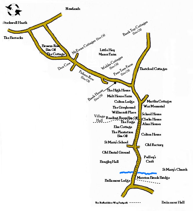
A Walk Through The Village
Hard copies of this walk are freely available from St Mary's Church, the two village public houses and at Rugeley Public Library.
A printable (pdf) version of this walk can be obtained by clicking here
Colton Village
Although Colton now appears to be a fairly insignificant village it has a long history with a lot of interest to offer.
It is a long, straggling village about two miles north of Rugeley. It is pleasantly situated on the banks of the River Trent and one of its tributary streams Moreton Brook.
The origin of the place name Colton is shrouded in mystery and there are a number of options to choose from. As each spot is named by its most marked characteristic then Martlin Hill is the feature which dominates the village. There is no doubt that the Col in Colton and Colwich are the same, possibly taken from the name of an early possessor, `Cola' or more likely from the old Norse 'colla' even Latin 'collis' both meaning hill. Ton in Old English times would have been a settlement or town but a town in those days equates to a village now.
Therefore Colton was the town at the neck of the hill. In addition some of the other theories are Coal Town, where coal was found, or Colt town, where colts were bred or even Cola as in the Old English name for charcoal. The earliest evidence of Colton's history is the Erratics. These are the stones found in the village and now placed at the four corners of Moreton Brook Bridge.
An erratic is a boulder transported and deposited by a glacier of a different type of rock than the bedrock. Erratics are useful indicators of patterns of a former ice flow and are about 120,000 years old.
The first evidence we have of human activity is from the Bronze Age about 2000 BC where `burnt mounds' have been found at Lount Farm. This is where stones were gathered and heated used and then discarded.
The first written record that we have is from Saxon times in the Domsday Book of 1086 which shows that the village was held by four thanes, Almund, Oda, Wulfric and Almaer. It had 300 acres of cultivated land, 35 acres of meadow, two woods and a water mill on the River Trent. It also had a priest, one of the few in Staffordshire so presumably a church. The village was worth 90 shillings. It was the biggest and most valuable village between Stafford and Lichfield.
This land was given to two Norman knights, Roger of Montgomery and Robert of Stafford for their services to William the Conqueror. They in turn let it out to Azeline and Geoffrey of Gastinois. At that time there were 29 families with 9 plough teams of oxen. Approximately 150 people.
In 1240 King Henry III granted the villagers the right to hold a Friday weekly market. The annual village wake would have been held on September 19th (Modern Calendar), where the population could have enjoyed a circus or funfair.
The close of King Henry Ills reign brought a spirit of lawlessness with villagers being involved in many robberies and at least 6 murders in the period from 1270 to 1306.
St. Mary's Church.
The tower is probably the oldest part of the building in the late Norman style. Other parts being of the Early English style of architecture of the 13th. Century.
Late 14th. Century frescoes were discovered beneath plaster when restoration work was undertaken in the 1850s by George Edmund Street, in what had been a chapel. One of the scenes depicted St. Nicholas. They were thought to have been painted in the time when Nicholas De Gresley was Lord of the Manor of Colton. St.Nichloas could have been his patron saint. Unfortunately these paintings were lost in the restoration but we do have drawings of them.
There are some small pieces of medieval glass in the windows of the tower. Medieval glass working went on in and around Colton in the 14th Century. In 1270 Nicholas son of William De Colton stabbed Adam, son of Hereward in a brawl; he fled to the church and took sanctuary. Lord De Colton assisted him in his escape before the villagers were able to hand him over to the proper authorities. They had to pay a fine.
The Rectory.
Standing with your back to the church and facing north to the left was the site of The Original Rectory. When the house was built the land was damp and low lying being near to running water and on the west side of the church. It was not conducive to the good health of its occupants.
At the beginning of the 19th. Century Rev. John Landor complained bitterly about the unhealthy environment for his family and maintained it had caused the death of 7 of his children. The family decided to finance the building of a new rectory (now known as The Old Rectory) on the east side of church away from Moreton Brook. In the 1970's it was sold as a private house and a new Rectory was built back on the west side of the church next to Moreton Brook! The front wall of the New Rectory would have gone through the original tithe barn.
Bellamour Hall.
Standing on the bridge with your back to the church looking to the left you can see the ruins of the first Bellamour Hall' built by Herbert Aston about 1635. Herbert was the second son and therefore did not inherit his father's lands but was given a small estate in Colton.
Friends of the impoverished Herbert, loaned or gave money to build the house known originally as Bellamore, later changed to 'Bellamour', French for 'good love' because of the affection his friends had shown him and to honour his wife.
It was supposedly at Bellamour and Tixall Halls that the Popish Plot was hatched in the 1690's. Herbert Aston and his brother Lord Aston were Catholics in the time when it was outlawed in this country. They along with Viscount Stafford was accused of plotting to kill the King. Viscount Stafford lost his head and Lord Aston was imprisoned but fortunately for him the plot was revealed as a hoax before he too lost his head.
The house passed by marriage into the Blount family in the 18th. Century. In 1796 Lady Blount had a second bigger Bellamour Hall built for her son Edward and the first Hall was let to tenants. In 1824 it passed into the hands of a retired Indian Judge, James Oldham Oldham and then on his death in 1857 the Liverpool M.P. Mr. T.B. Horsfall bought it. He improved and extended the estate creating in the process one of the finest gardens of that time inStaffordshire. The second hall was sold in 1921 and demolished soon after.
Bellamour Lodge.
Looking round to the right you can see Bellamour Lodge. This house was built in the Victorian style by James Oldham Oldham in 1851 for his unmarried daughter Ellen to live in. About 20 years later it was enlarged on the eastern side and the veranda erected.
Moving again to the right some five hundred yards up School Lane are the Boughey Hall Farm buildings on a site occupied from 1246. At one time it was a Grange for St Thomas's Priory in Stafford. A Grange provided all the food and the dues went towards the upkeep of the Augustinian order. The priory ownership of the Grange came to an end with the dissolution of the monasteries
by Henry VIII, and so in 1539 the Priory and all its lands were given to Bishop Lee.
Soon after it passed to the Boughey family who gave it its present name. In 1694 Constance Boughey married Thomas Whitgreave of Moseley Old Hall. He had been instrumental in helping Charles II escape from the Battle of Worcester. From 1923 the farm changed hands two or three times until finally in the latter half of the 1990's it was bought and converted into separate dwellings. Whilst the main house was undergoing renovation, evidence of an earlier cruck house, was found inside the present one.
St. Mary's School.
Walking up the road away from the church The School is on the left hand side. Although children have been educated in Colton since at least 1764, Mr Horsfall donated the land and built the present school in 1862. When it opened pupils had to pay for their education, labourers children 2d per week for the first child and 1d for other children in the family.
Colton House.
Further along Bellamour Way is Colton House. The Queen Anne style is of the early 18th. Century. William Pigott, a gentleman of good family who kept harriers lived there in the 1770's. In 1795 a West Indian sugar planter and merchant John Heyliger Burt was there. He died when his ship disappeared on a voyage back from St Croix where his estates were.
In the 1851 census a boy's school for 11 borders is being run in Colton House by Mr. Mills. There were 18 people living in the house at that time. In 1896 Frederic Bonney was in
occupation. He was a keen photographer and whilst visiting his brothers who were farming in Australia he took some of the first pictures of Aborigines. He was also a keen gardener, creating a considerable arboretum around the lake that is opposite the house. He recorded with his black and white photos many of the events happening during his time in the village.
In the Second World War the army occupied the house with soldiers stationed there. After the war the house was converted to flats, after that it was owned by Lichfield Laundry, many people in the village have stayed there. In the 1970s what were the pigsties' and stables were rebuilt and the coach house converted for modern day living.
Elm Cottage.
Moving along and looking to the left is Elm Cottage. This was built at the same time as the school in order to house the Headmaster. It was built looking down towards the school so that the Head could keep an eye on what was happening.
The Forge.
Next door to Elm Cottage was The Forge, built by Mr Horsfall for the Bellamour Estate and probably on the site of a much earlier one. For many years it was also
where coffins were made for the villagers. It became a private house in the 1980's.
Williscroft Place.
Mr Coxe a solicitor built Williscroft Place in 1858 as a speculative venture on farm land used by the Williscroft family.
The Greyhound.
The Greyhound was built about the same time as Williscroft Place and became an Inn after 1883 on the demolition of the Bell Inn just opposite. Through the 19th and early 20th Century there was a butcher's shop standing on what is now the front right hand part of the Greyhound car park.
Alms Houses.
Across the road are the present day Alms Houses. Originally the Three Wheels Inn renamed The Bell Inn used to stand on this site. This building belonged to the Webb Trust; the rent obtained went towards financing the school. Recorded in the school log book in the 1870's is how the Publican, William Brazenell, was keeping a noisy house where fights were taking place. He almost lost his licence. Eight almshouses were erected in 1884 by Mrs. Harland in memory of her sister Miss Oldham of Bellamour Lodge. These were completely refurbished in 2003 and changed to four to bring them up to modern day standards.
The Clerks House.
Next door is The Clerks House. The Clerk's Trust is the oldest charity in Colton; the house was built for the Clerk to the Parish Church. The present house was built in 1845 on the site of an earlier one. You can see the date written in brick into the sidewall.
School House Cottage.
Further along is School House Cottage. This was originally one building and housed Colton's first free school for boys and girls. The building was owned by the Webb trust, a trust established by a local farming family. The 1841 to the 1861 Census records the Head as Mr. Lenton he was helped in the school by his wife and daughter as schoolmistresses and one other master. The house was their living quarters as well as the school.
The War Memorial.
Next to School House Cottage is the War Memorial, originally the site of the village pound where any stray animals caught wondering around the village would be held until their owners collected them. Now it is a memorial to those residents of Colton who lost their lives fighting in the 1st. and 2"d. World Wars. William
Yates for instance, lived at Bank House, Colton and was fatally wounded at the Battle of Ypres aged 17 years and 8 months.
Martlin Lane (Martlin Cottages).
Martlin Lane runs up from the war memorial. The Rector of Colton Rev. Parker and his sisters built these cottages in 1904 because they did not think that there was enough good accommodation at a reasonable rent in Colton for 'decent working
families'. Number 1 at the far end was also at one time the village Post Office this was run by Mrs Deakin and before her Mrs Tooth.
Little Hay Manor.
Little Hay Manor The house on this site today is a 19th century building but the occupation of this site is ancient. It is believed to be the smallest of the three manors recorded in the Domesday Survey of Colton which means that it was occupied in Saxon times. From the 14th to the 20th. centuries it was owned by the Bagot family of Blithfield. The chimney still standing in the garden is all that remains of the house that stood here in Elizabethan times.
Webbs Cottages.
Webb's cottages. It is thought that when John Webb left money in his will in 1811 to "educate 20 poor girls of Colton", their schoolroom was in these cottages. In 1862 it was amalgamated with the boys school to form the Colton United School.
Reproduction of this publication in whole or in part without prior approval of the Society is strictly forbidden.
Copyright Colton History Society 2007-2023
|